Understanding Wildfire Smoke Maps: Your Guide to Safety
The Importance of Wildfire Smoke Maps
With the increased frequency of wildfires across Canada and the United States, understanding the impact of smoke on air quality has become crucial. Wildfire smoke maps provide essential information about the geographic spread of smoke, enabling individuals to monitor air quality and make informed decisions regarding health and safety. As climate change continues to exacerbate wildfire seasons, the relevance of these resources grows significantly.
Current Situation in Canada
As of October 2023, numerous regions, particularly in British Columbia and Alberta, have been impacted by historic wildfire outbreaks. This season has seen a record number of fires, leading to widespread smoke that has affected air quality in urban and rural areas alike. The Canadian government, alongside various environmental agencies, has been actively providing updates on current wildfire statuses and corresponding smoke dispersal maps.
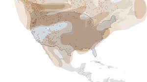
How Wildfire Smoke Maps Work
Wildfire smoke maps are created using satellite imagery, weather data, and ground-level monitoring. These maps show the density, trajectory, and potential impact of smoke, which varies based on prevailing weather conditions and geography. Resources such as FireSmoke.ca and the U.S. Air Quality Index (AQI) provide real-time updates and forecasts regarding smoke movement, allowing communities to prepare accordingly.
Protecting Your Health
When smoke levels are high, the health risks associated with inhaling particulate matter can increase, particularly for vulnerable populations such as children, the elderly, and those with pre-existing health conditions. Authorities recommend that individuals monitor local air quality indices and reduce outdoor activities when smoke is prevalent. Using N95 respirators or staying indoors with air filtration systems can help mitigate risks during periods of poor air quality.
Looking Ahead
The ongoing fire season and associated smoke events emphasize the need for continued vigilance and preparedness. As climate patterns shift, the trend of increasing wildfires may persist, making wildfire smoke maps an invaluable tool for public safety. Awareness and education on how to read and interpret these maps, including understanding markers like AQI levels, will empower more Canadians to take proactive measures in safeguarding their health.
Conclusion
In conclusion, staying informed about wildfire smoke through accurate maps and resources is essential. As wildfires continue to pose a significant threat, being aware of air quality can prevent health complications and promote community safety. By leveraging technology and accessible information, Canadians can better navigate the challenges posed by wildfire smoke.