Understanding Wildfire Smoke Maps: 2023 Updates and Impacts
The Growing Concern of Wildfire Smoke
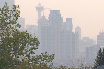
In recent years, wildfires have become increasingly prevalent in Canada and around the world, largely due to climate change, forest management practices, and prolonged drought conditions. The smoky haze resulting from these wildfires poses significant health risks, prompting a need for reliable resources such as wildfire smoke maps that allow communities to track air quality and exposure levels.
Recent Developments in Wildfire Smoke Tracking
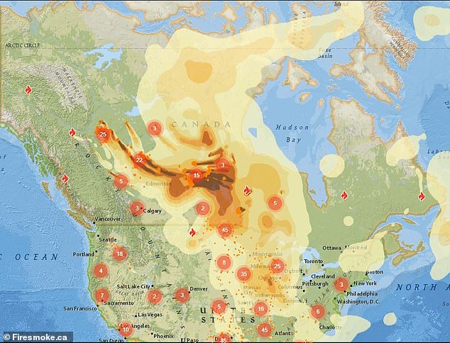
As of October 2023, ongoing wildfires in parts of British Columbia, Alberta, and the Northwest Territories have led to the production of updated wildfire smoke maps. These maps, created by organizations such as Environment Canada and Health Canada, provide real-time data on the extent of smoke coverage, the concentration of hazardous particulates, and forecasts for various regions. With the prevalence of smartphones and the internet, accessing this vital information has become easier than ever for Canadians seeking to protect their health.
Health Implications
According to the latest reports, exposure to wildfire smoke can lead to respiratory issues, worsened cardiovascular conditions, and other health risks, particularly for vulnerable populations such as children, the elderly, and individuals with preexisting health conditions. The **Air Quality Health Index (AQHI)**, often used alongside smoke maps, helps Canadians understand the severity of air pollution on any given day and take necessary precautions, such as staying indoors or using air purifiers.
How to Access Wildfire Smoke Maps
Canadians can access wildfire smoke maps through various online platforms. Environment Canada’s website provides interactive maps that illustrate current smoke conditions across the provinces. Additionally, mobile applications like **AirVisual** and **IQAir** give users access to localized air quality information, including wildfire smoke data. Regularly checking these resources can help individuals make informed decisions to safeguard their health during wildfire season.
The Future of Wildfire Smoke Awareness
As climate conditions continue to shift and increase the likelihood of wildfires, the development of accurate and user-friendly wildfire smoke maps will be essential. Experts advocate for the improvement of predictive models and better communication strategies to inform the public about the risks associated with wildfire smoke. The collaboration between government agencies, scientists, and technology developers will play a crucial role in enhancing the effectiveness of smoke tracking systems.
Conclusion
The significance of wildfire smoke maps cannot be overstated, especially in an era of increased wildfire occurrences. By staying informed through real-time data and understanding the health effects of smoke exposure, communities can better protect themselves during wildfire events. As we look towards the future, enhancing smoke tracking technologies will undoubtedly contribute to public safety and environmental awareness as Canada faces the ongoing challenges posed by wildfires.