Understanding the Smoke Map in Ontario: A Vital Resource
The Importance of Smoke Maps in Ontario
As wildfires become increasingly prevalent due to changing climate conditions, monitoring air quality has never been more crucial. The Smoke Map Ontario is an essential tool that provides real-time updates on air quality impacted by wildfire smoke. This resource not only assists residents in making informed decisions regarding outdoor activities but also helps vulnerable populations protect their health.
What the Smoke Map Shows
The Smoke Map is developed and maintained by Environment and Climate Change Canada and provides vital information about the concentration of airborne particulate matter, specifically PM2.5, which can pose significant health risks. Users can view detailed maps that display current smoke conditions across the province, allowing them to check the air quality index (AQI) in their specific area.
Recent Developments and Statistics
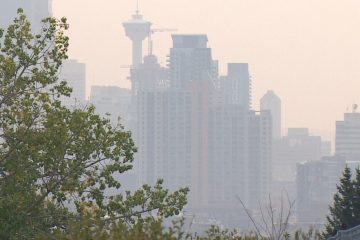
This year, Ontario has faced numerous wildfire outbreaks, largely attributed to hotter and drier weather patterns. As of August 2023, there have been over 1,200 wildfires that have burned more than 200,000 hectares of land in Ontario alone. As a direct result, air quality in urban centers including Toronto, Ottawa, and Hamilton has frequently dropped into unhealthy ranges.
According to data from Health Canada, particulate matter levels have been recorded well above recommended limits during peak wildfire season, leading to health advisories that warn residents of potential respiratory issues. In July 2023, the AQI in Toronto reached alarming levels, advising sensitive groups to avoid outdoor activities altogether.
How to Use the Smoke Map
Residents can access the Smoke Map Ontario through official government websites or via mobile applications. The interface is user-friendly, offering options to view both current and forecasted smoke conditions. This interface aims to inform the public about safe outdoor timing and encourage protective measures, such as wearing masks or avoiding strenuous activities outdoors when air quality worsens.
Conclusions and Future Implications
The Smoke Map Ontario is a critical tool for safeguarding public health during wildfire season. As climate change contributes to more frequent and severe wildfires, the importance of accessible and accurate information will become increasingly vital. Residents are encouraged to stay informed, use the Smoke Map regularly, and advocate for improved air quality management and fire prevention strategies.
For the foreseeable future, the Smoke Map will remain a necessary resource, as ongoing efforts to tackle climate-induced wildfires continue. Public awareness and real-time monitoring will play a key role in protecting citizens from harmful air quality impacts.