Understanding the Importance of Wildfire Maps
The Growing Importance of Wildfire Maps
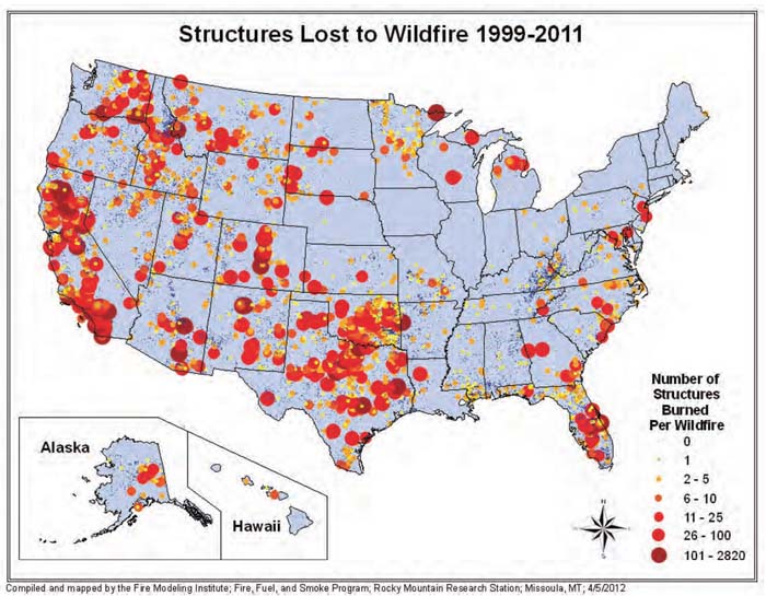
As climate change accelerates the intensity and frequency of wildfires, the ability to track these events has become increasingly important. Wildfire maps provide critical information about the locations, sizes, and potential dangers associated with wildfires. They are invaluable tools for both first responders and communities at risk, as they facilitate timely evacuations and resource allocation.
Current Events in Canada
In 2023, Canada has seen significant wildfire activity, particularly in western provinces like British Columbia and Alberta. As of mid-October, the Canadian Interagency Forest Fire Centre reported over 5,000 wildfires this year, burning more than 1.5 million hectares of land. These fires have contributed to poor air quality, prompting health warnings and advisories across several regions.
Furthermore, the recent launch of an interactive wildfire map by Natural Resources Canada allows citizens to monitor active wildfires in real-time. This advanced tool includes features such as fire perimeter updates, smoke forecasts, and evacuation alerts, serving as a critical resource for families living in affected areas.
Utilization and Accessibility
Wildfire maps are not only used by firefighters and emergency services; they are also accessible to the general public. Mobile applications and government websites now provide real-time updates, utilizing data from satellites and ground reports to ensure accuracy. Residents can use these maps to prepare, stay informed, and make decisions based on the proximity of wildfires.
Conclusion: The Future of Wildfire Management
As wildfires continue to pose a threat to ecosystems and human lives, the science behind wildfire maps is expected to evolve. Advances in technology, such as satellite imagery and artificial intelligence, may enhance the accuracy and responsiveness of these resources. It’s vital for communities to remain aware and utilize these tools to mitigate risks associated with wildfires. Keeping updated with the latest wildfire map information can save lives and property while fostering a culture of preparedness in the face of fire-related threats.