Understanding the Gulf of Mexico Map and Its Features
Introduction
The Gulf of Mexico is a crucial body of water located between the United States, Mexico, and Cuba. Its intricate geography is not only vital for navigation and maritime activities but also plays a significant role in the local economy, marine biodiversity, and climate. Understanding the Gulf of Mexico map is essential for various stakeholders, including fishermen, tourists, environmentalists, and researchers. Recent studies and events highlight the significance of this region, making it all the more relevant to discuss the geography and features that define it.
Geography and Coastal States
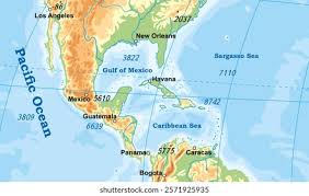
The Gulf of Mexico spans approximately 600,000 square miles and is characterized by a diverse landscape consisting of vast open waters, shallow continental shelves, and rich coastal ecosystems. The states bordering the Gulf include Texas, Louisiana, Mississippi, Alabama, and Florida in the United States, while Mexico’s coastline also hugs the western edge. Notably, the map of the Gulf showcases key cities such as New Orleans, Houston, and Miami, which are pivotal to trade and tourism.
Significant Features
The Gulf of Mexico is home to several important natural and human-made features. The Mississippi River, one of North America’s largest rivers, discharges into the Gulf, influencing its ecology and economy. The region also boasts the Florida Keys, a stunning coral archipelago, and the Yucatán Peninsula, known for its rich biodiversity and Mayan ruins. Moreover, the Gulf is a vital area for oil and gas exploration, being one of the world’s richest offshore oil sources, evidenced by numerous drilling platforms marked on the Gulf map.
Environmental Concerns and Conservation Efforts
Despite its wealth of resources, the Gulf of Mexico faces numerous environmental challenges, including oil spills, overfishing, and the impacts of climate change. The 2010 Deepwater Horizon oil spill serves as a grim reminder of the potential hazards associated with oil extraction. Recent initiatives by both governmental and non-governmental organizations aim to restore marine habitats and promote sustainable fishing practices within the region. The updated Gulf of Mexico map incorporates protected areas, highlighting these conservation efforts.
Conclusion
The Gulf of Mexico map is more than just a geographical representation; it encapsulates a complex interplay of ecosystems, economies, and cultures. With ongoing environmental challenges and a focus on sustainable practices, understanding the geography of the Gulf is imperative for future generations. As new data emerges regarding climate change and marine health, the Gulf of Mexico will undoubtedly remain a focal point for discussion among policymakers, environmentalists, and the public alike. So whether you’re a local resident or a visitor, exploring the Gulf’s map reveals a wealth of knowledge and adventure, urging us all to play a role in preserving this vital area.