Understanding the Wildfire Smoke Map and Its Importance
Introduction
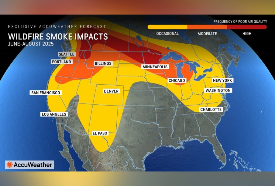
Wildfires have become increasingly common across Canada and the United States, leading to significant health and environmental concerns, particularly regarding air quality. With many regions grappling with the effects of smoke and pollutants, the availability of a wildfire smoke map has become a vital tool for residents and authorities alike. This mapping service provides real-time updates on smoke dispersion, helping individuals to make informed decisions to protect their health.
Recent Developments
As of 2023, the wildfire season has been exacerbated by climate change, resulting in longer-duration wildfires and an increase in affected areas. Systems like the Canadian Wildfire Smoke Prediction System (CWSP) have enhanced the accuracy of smoke mapping, offering forecasts of smoke trajectories, intensity, and subsequent air quality indexes. These updates are critical, particularly in areas where residents may be susceptible to air pollution, such as those with pre-existing health conditions, children, and the elderly.
In recent months, the smoke map has tracked significant wildfires across provinces like British Columbia and Alberta, where smoke has traveled hundreds of kilometers affecting air quality as far as the east coast. For example, meteorological data indicated that wildfire smoke from British Columbia reached central Saskatchewan, leading communities to issue health warnings and advisories. Local governments are using this information to issue guidance on reducing exposure, especially for vulnerable populations.
Key Features of the Wildfire Smoke Map
The wildfire smoke map not only shows the geographical extent of smoke but also includes essential air quality indicators. Users can find:
- Current Conditions: Real-time updates on smoke density and visibility.
- Health Advisories: Recommendations based on air quality levels, indicating when it is unsafe to be outdoors.
- Forecasts: Predictions about how smoke will spread over the next few days, enabling communities to prepare thoroughly.
- Alert Systems: Notification services that provide instant updates to those in high-risk areas.
Conclusion
The wildfire smoke map is proving to be an indispensable resource for managing public health in the face of increasing wildfire activity. As climate patterns continue to shift, leading to more frequent and severe wildfires, access to timely information about smoke exposure will remain crucial. Residents are encouraged to stay vigilant and use the smoke map as a guide for outdoor activities, especially during peak wildfire season. As forecasting technology continues to improve, it is expected that the reliability and accuracy of these maps will only enhance, thereby helping communities stay informed and safe.